


Cleethorpes
The Boy with the Leaking Boot
A statue of the boy with the leaking boot was presented to the town in 1918 by John Carlborn. It is reported that he was a Swedish immigrant to Cleethorpes who had built up a successful shipping business, and that the statue was a copy of one in the a restaurant in Stockholm in Sweden. The Cleethorpes statue once stood in the Pier Gardens but is now in the town hall, with a replica on display in the Tourist Information Office. The statue is also on display on the sea front close to the leisure centre in the Diana, Princess of Wales, memorial garden.
Meggies
Local residents from the area affectionately refer to Cleethorpes as Meggies. It is very unclear where the name comes from.
Some say that Isaac's Hill used to be called Meg's Island and that it was a fishing hamlet..
One story passed down through the generations is that anyone born on or above the hill in Cleethorpes bore the right to be called a Meggie. For many years there were two local maternity homes in Cleethorpes, St Huges, which was on the hill and Croft Baker, which was above the hill in Mill Road. Thus most children born in Cleethorpes were , by birth right, a Meggie. However, with the relocation of the maternity unit to the Grimsby Hospital Site, very few Meggies are now being born.
Others say a meggie was the cost of a tram fare from Grimsby to the resort.
There is yet another theory, that the term Meggie has its origins in the military history of Lincolnshire. Towards the end of the 19th century, the local commandant of the 1st Volunteer Battalion of the Lincolnshire Regiment was Captain H W Meggitt. Thus the volunteers adopted the term Meggie to distinguish them from the Yellowbellies of the Lincolnshire Fens."
Which ever you choose to believe - is your choice, but having these legends continue down the generations is lovely, and makes all "us Meggies" feel very proud of our heritage and ancestry.
Grimsby
Grimsby was founded by Danesin the 9th century AD. However there is evidence of a small town of Roman workers sited in the area around seven centuries earlier. Located on The Haven, which flowed into The Humber, Grimsby would have provided shelter for ships from approaching storms. It was also well situated for the rich fishing grounds in the North Sea.
The name Grimsby probably originated from the Grim's by, or "Grim's Village". This is based on Grim the Viking, supposedly the founder of the town, with the suffix -by being the word for village.
In the early 19th century, the town grew rapidly. The arrival of the railway in 1848 made it far easier to transport goods to and from the port. Coal which was mined in South Yorkshire was brought by rail and exported through Grimsby. Rail links direct to London and Billinsgate Fish Market allowed fresh 'Grimsby Fish' to gain its excellent reputation nationwide. The demand for fish in Grimsby grew to such an extent that, at its peak in the 1950s, Grimsby laid claim to the title of 'the largest fishing port in the world'. Many of the exclusive properties in Grimsby and Cleethorpes were built for local fishing families, such was their affluence.
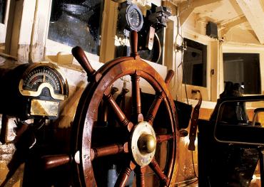
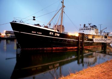
Grimsby's trawling days are remembered through the artifacts and exhibits seen at the town's Fishing Heritage Center. The preserved 1950s trawler, Ross Tiger, is moored adjacent to the museum. Very few fishing vessels still operate from Grimsby's once thriving docks, although the town does maintain a substantial fish market, of European importance.[
Today, Grimsby is home to around 500 food-related companies making it one of the largest concentrations of food manufacturing, research, storage and distribution in Europe.
Grimsby Dock Tower
Grimsby Dock Tower is a hydraulic accumulator tower and a famous maritime landmark.
The tower system was brought into use in 1852 working the machinery of the lock gates, dry-docks and fifteen quayside cranes, and also to supply fresh water to ships and the dwelling houses on the dock premises. The water was obtained from a well nearby.
The tower was designed by James William Wild. It was built under the supervision of J. M. Rendel, who was the civil engineer in charge of construction of the Royal Dock.
The ground floor of the tower was lined with pink, white and blue drapery when Her Magesty Queen Victoria came with Prince Albert to visit the dock to 'open' the tower in October 1854. She gave permission for Prince Albert, the Prince of Wales and the Princess Royal to accompany Mr Randel in the hydraulic lift to the gallery around the tower above the water tank, from which a clear view of Grimsby, Cleethorpes and the mouth of the River Humber is possible. The lift is no longer in operation. Access to the top is via a spiral staircase in one corner of the building. The second balcony is currently used for the transmission and reception of radio signals.
For many Grimbarians, the structure is the true monument to the town's heritage and marks their arrival "home". The Dock Tower is visible from miles around. Today, people abseil down the side of the tower to raise money for charities and good causes, although it is generally not open to the public.
There is a model of the Grimsby Dock Tower entirely constructed of Lego, at Legoland in Windsor. The tower itself is correct, however a large building has been incorrectly added to the base of the tower.
Fishing heritage centre
Bull Fort and Haile Sands Fort
The two Humber forts, Haile Sands Fort and Bull Fort, which stand off Cleethorpes in the mouth of the Humber Estuary were built during the First World War to protect the Humber against attack from Germany.
The enormous construction project, estimated to have used up to 40,000 tons of concrete and steel per fort, began following the outbreak of war in August 1914 and took three years to complete. When finished Bull Fort, standing 80 feet in diameter and 50 feet above high water, could accommodate a garrison of 200 men with arms, stores and equipment. Haile Sands Fort is slightly smaller. The work had cost approximately £2 million and was in its day,considered to be a major engineering triumph.
The irony was that by the time the fort was ready for use the war was reaching its conclusion and the fort's guns were never called into action. However, they remained a deterrent to the enemy during the Second World War when both forts were continually attacked.
In the present day, Bull Fort is used as a navigational aid.
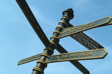
Greenwich Meantime Meridian Line
In 1884, zero degrees longitude was established by International agreement as the Greenwich Meridian and the world's prime meridian for measuring longitude and for establishing a standard time reckoning throughout the world.
The Greenwich Meridian line runs through Cleethorpes as it travels round the globe from north to south, and a metal plate has been set into the coastal path to mark the exact location. You will find it behind Pleasure Island Theme Park.
Presented to Cleethorpes by Sheffield Foundry it was set down during the 1930s and also marks the distance between the Meridian and various places around the world. These include: North Pole - 2517 miles, New York - 3481 miles, London - 143 miles and Sydney 10483 miles.
A definite photo opportunity. And very popular as a destination for families and friends to meet on New Years day.
Ross Castle
What appears to be the ruins of an ancient castle in the Centre of Cleethorpes Promenade is in fact a folly built in 1863. As Cleethorpes was being developed as a holiday resort, following the arrival of the railways during the 19th-century, the Manchester, Sheffield and Lincoln Railway Company built a one mile long promenade iin the resort to prevent continuing coastal erosion of the cliffs on which the town was sited.
Above the promenade the rail company decided to build the mock ruin as a visitor attraction and it was named Ross Castle after the company's secretary Mr. Edward Ross.
The views from Ross Castle across the Humber are superb.
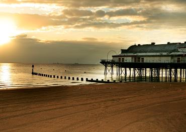
Pier
The Pier was originally built in 1872 by Head Wrightson at a cost of £8000. Measuring 1200 feet it was officially opened on August Bank Holiday 1873.
Fifteen years later a concert hall was added at the Pier head but unfortunately this was destroyed by fire in 1903. The pavilion which exists today was built in 1906.
Visitors may wonder why the pier is considerably shorter than its original length and today is only 355 feet long. During World War II, measures to combat enemy invasion meant that a middle section of the pier was removed and later the Government were not able to afford its replacement. As a result the isolated seaward section was demolished.
The Pier has hosted many enterprises in recent years and is now a restaurant and events venue.